Tasmania's remote southwest is accessible only by boat or light plane, as there are no roads in this part of the state. The hour flight from Hobart down the D’Entrecasteaux Channel, then out along the Southern coast and on to Melaleuca/Bathurst Harbor is awe-inspiring: as civilization falls off, as it does abruptly at Recherche Bay and Cockle Creek, the immensity of the transition into complete wilderness is incomparable. The exposed Southern coast takes the full brunt of the winds that blow in hard from the west and directly from Antarctica to the south, some 1600 miles away. The elements conspire to make this a raw and primal place of inexhaustible energy, with violent seas and staggering rock formations. Many places along the Southern coast offer not so much as a foothold for a boat landing, and it is no wonder that-- as accounts have it—the first European explorers were frightened by this uncompromising geology. Our Cessina shimmied as it headed into the strong oncoming winds from the South East Cape, and our flight path, hundreds of feet above the coast, skirted along the notoriously perilous South Coast Track, a 5-7 day bushwalk that starts at Cockle Creek and finishes at Melaleuca. It took us less than 15 minutes to fly over the entire walk. Flying in and out of Melaleuca up to 1500 times a year, not only to ferry tourists, but also to bring in resupplies to bush walkers, our pilot commented that too many times he has had to rescue people in Melaleuca who were ‘half dead’ or in a bad way, unprepared both physically and emotionally for what walking the daunting South Coast Track had thrown at them. It is the vagaries of weather conditions that make this part of the world so particularly hazardous. We turned inland at Cox Bight to land at Melaleuca's short, sparkling white quartz landing strip, set back from the coast in open buttongrass plains.
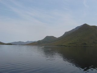
Melaleuca and Bathurst Harbor's pristine environment is otherworldly; how exalting to contemplate the passage of time in a place essentially unchanged since the last ice age. Ten thousand years ago, Bathurst Harbor--equal in size to Sydney Harbor today--was but a small river. We took a boat across the harbor and I was struck by how absolute the silence was. The water is whiskey-colored due to tannins from the tea trees that comprise much of the vicinity’s low-lying coastal vegetation. The soil here is poor and the huge amount of rainfall is one other factor that makes bush walking around the area so difficult-- the ground can quickly turn to mud, and lots of it. But our day was dry and hot; on-going bush fires in the Franklin-Gordon area and Strahan, further to the north, turned the air oily and thick; distant panoramas of the spectacular Arthur Range and the outlying headlands along the harbor were matted into a haze of ever subtler purples and grays.